statcounter

Friday 28 November 2014

Howling in the Dark and Misty Night (Kirkcarrion with Chrissiedixie and The Hounds….. Oooer…

looming....

Ok, actually it wasn’t nearly as scary as it was supposed to be. Me and Chrissie and her dog-not-called-Dixie-but Tilly drifted into a plan to spend the night in the notoriously haunted Kircarrion – a gloomy and occasionally spooky clump of trees often looming in a menacing kind of way over the junction between Teesdale and Lunedale.

what kirkcarrion really looks like

So, we met at Bowlees in order to have a walk – Me, Lucky (perhaps an ironic name on this occasion…?) and a huge brown labrador called Tilly. And after coffee in Chrissie and Geoff’s van, we set off into the gloom and drizzle of a grey November lunchtime. Tilly’s hobby, by the way, is getting wet and goes enthusiastically into any water that’s available We all need an interest , innit…? Lucky only gets wet by accident and walks around puddles and mud if possible.

wobbly bridge and wobbly lucky

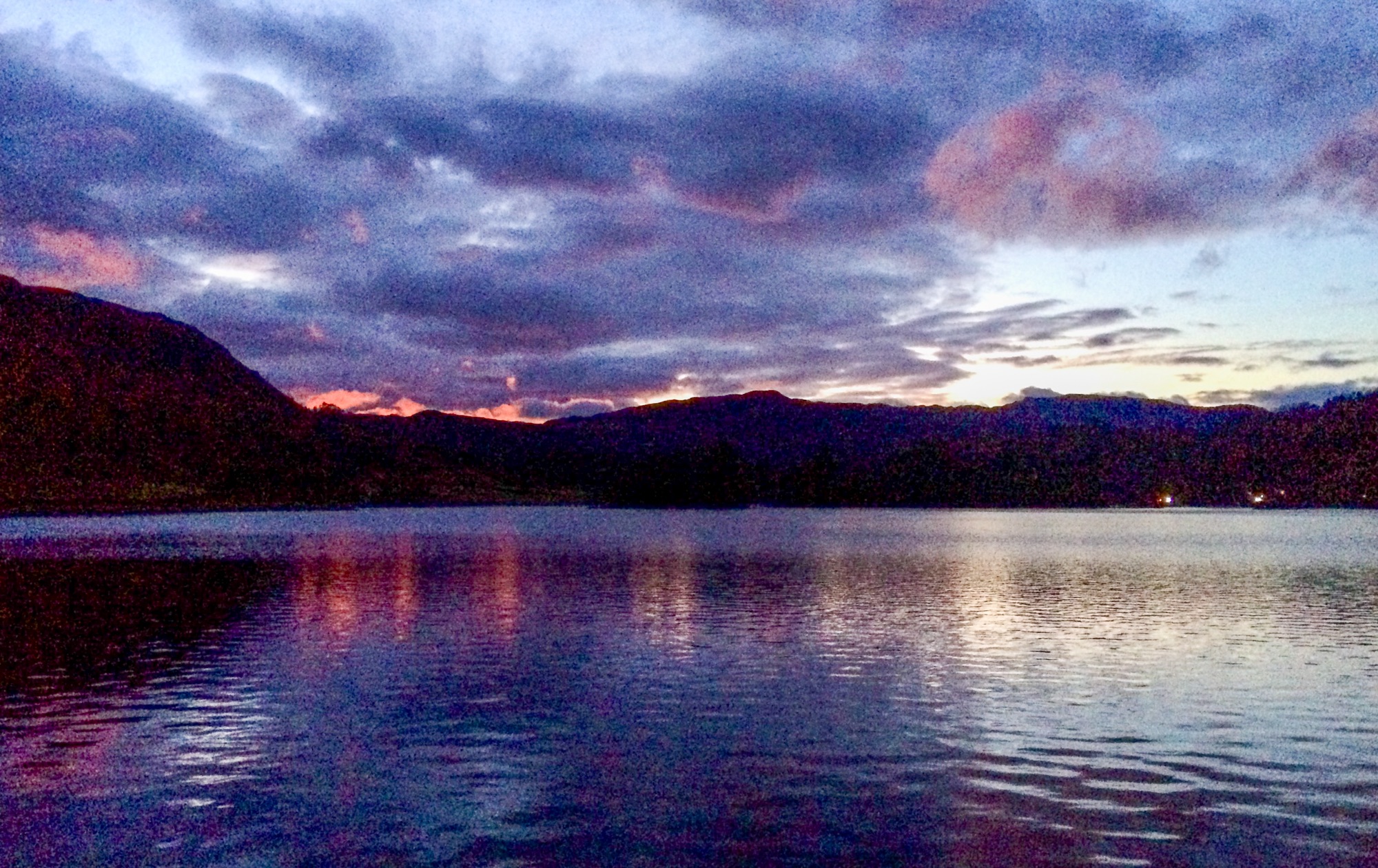
It was very gloomy, grey and drizzly. I may have already mentioned this above and I’ll probably mention it again below.

chrissie crossing crossthwaite common

We slithered off over the wobbly bridge (aka Wynch Bridge) and up the paths to Holwick and thence up The Steep Bit onto Crossthwaite Common – into deep and driving hillfog – the kind of stuff which may well appear in a horror story or a tale of a mysterious double disappearance. However, due to my superb navigational skills [koff], we managed not to get lost all that much and eventually, having wandered through deep and raging streams, across quaking bogs and having teetered on the Very Edge of Oblivion a couple of times (it was a bit slippery), the haunted trees of Kircarrion finally loomed into view out of the gloomy grey drizzle (see above).

kircarrion (oooer...)

Just, in fact, as the last vestiges of gloomy grey and drizzly daylight seeped out of the ..er.. day, I managed to  locate the basha and ten litres of finest Weardale tapwater wot I’d hidden under some bracken a couple of days previously and we threw up the tents (take this phrase to mean we set up the tents, not that we’d previously eaten the tents and they were now making us ill) (although if one did try to scoff an akto there could certainly be unpleasant consequences – just sayin…)

camp

As we waited in the darkness (and drizzle etc) for a decent interval before starting dinner, we discovered that both Tilly and Lucky could be made to howl quite easily by the deft use of a bit of human howling. I suspect that this short episode of unearthly hounds-of-the basketcase stuff was probably one of the reasons we weren’t disturbed by any local farmers or shepherds that night.

And That Night was a long one and almost unremittingly gloomy, grey and drizzly (see above and below , but not at the same time or you’ll crick your neck)

There was a brief period when the lights of Middleton-In –Teesdale appeared, but generally it was you-know-what.

At one point an owl sat in a tree quite close by and hooted. Another owl somewhere else hooted in reply and the two met and left sharpish, showering the tents in water from the tree branches they disturbed. Later, another owl Too-witted but didn’t Two-woo…

So, to celebrate, I had a brew and shared some cheese and oatcakes with the Pooch.

tilly with a stick lucky scares a rabbit

In the morning, guess what it was like….. to help with this question , I’ve inserted the initial letters of the weather conditions here as a clue.  G_______, G_______ and D________

heading back on the pennine way

We packed up and left at tennish after a slow start and returned to Bowlees along the Pennine Way where that path could best be described as “clarty”

Chrissie and Geoff are away for more adventures with James Backpackingbongos and , no doubt, Reuben. Hopefully, the weather will brighten up a bit.  I’ll post links to their blogs as soon as they are available.

Eleven miles and No Ghosts (unfortunately) (or maybe not) (Oooer)

kirkcarrion camp

Print

Monday 24 November 2014

Birkett Common Second Go - and Wild Boar Fell

DSCN2387
Due to being seriously put off from bagging the very lovely Birkett Common on Dawn and me and Lucky’s camping jaunt the other day by some pretty duff weather, me and the pooch decided to return to Kirkby Stephen to have another go.
The knipemobile was parked in a patch of mud on the newly rebuilt minor road across Wharton Fell and wandered off to collect our top.
erratic on birkett common
Birkett Common, it turns out, is a rather nice Carb limestone top littered with a few lake-District type erotic boulders and some lumps which would only really qualify as “stones”. And it has a very nice view of the Upper Eden valley as well.
on the way up...
sunny howgills
and misty mallerstang
Having got this off my chest, I wandered up the long ridge which eventually ends up at the top of Wild Boar Fell. This was covered in hill-fog but over to the West, the Lake District was all shiny and golden in lovely sunshine and soon, the Howgills too shrugged off their fluffy mantle and shone proudly in the sun. Wild Boar fell, meanwhile hung on to it’s cloak until we’d got to the summit area when the mist lifted suddenly and we were bathed in the golden glow etc and so on.
near the top
This was in stark contrast to the last time me and Lucky were on this ridge – when we crossed it against  with Dawn on a wet and windy Wednesday a week (ish) ago. Conditions today were, in fact quite civilised and this way is quite a good route for climbing or descending Wild Boar fell
trig point damage
It wasn’t warm, though. In fact it was nithering. We lunched at the trig which some hungry hiker appears to have had a big bite of, and then splodged through the bogs back to Eastern edge – the one with the lovely view of Mallerstang.
It was here that my camera stopped working. I struggled to get that last picture – taking out the batteries and warming them up only to be foiled time after time by the cold and the lack of electricity in them.
mallerstang from the eatsern escarpment
Eventually, whilst the pooch whinged, shivered and complained, I finally got the picture and we headed off back down the long ridge in double-quick time.
On the way home, I also bagged Ash Fell – a summit with a trig and two tumuli and a stupendous view of the Northern part of the Howgills, just as the sun began to set. My camera wouldn’t let me take any more pictures, though, so, with a grumpy heart and Lucky’s last winalot biccie safe in my pocket, we returned over the Pennines back to Pieland.
Note self: Try to remember that this route would be quite good as a walk between Garsdale head  and Kirkby Stephen train stations. Just sayin’…
Nuther note to self: Get some spare batteries for the camera, idiot….
We did about 9 miles.
wild boar fell
Print

Friday 21 November 2014

Teesdale Railway and Riverside Paths -Doing The Same Walk Twice Sans Fashion Tips (sorry)

on the teesdale railway path near mickleton

When I lead a guided walk, I have to do the walk as a reccy about a week before the actual event so that I can see if there’s likely to be any “issues” – and also to see if I can actually remember where the walk goes…

So, just before our damp little adventure in the Dales, I had a damp little adventure in Teesdale.

The reccy at least started in lovely, bright sunshine and the guided walk didn’t (it was wet).

I seem to remember there being just me and the pooch on the reccy and me and 15 or 16 hardy and waterproofed souls on the walk….

Incidentally, I must apologise to readers of TGO magazine about the lack of fashion tips in the blog post. And nobody is wearing pink wellies. Lucky, though is wearing his new ruffwear harness…..

DSCN2324

Lucky senses a walker coming the other way – Riverside path at Middleton in Teesdale

Steep drop.....

Steep and slippery bits high above the river

DSCN2330

Lucky has just buried his snack (a bonio (nom nom)) and is sitting on it (note the dirty nose)

DSCN2332

Bridge at Cotherstone and fearty dog

DSCN2345

Middleton bridge – a bit surprised anybody turned up in these conditions. Kirkcarrion looking sinister as usual…

DSCN2346

Picnic in Egglesburn nature reserve. (blurred cos I was probably shivering…)

DSCN2347

Goldsborough in the distance….

DSCN2348

Brightening up….

DSCN2349

Sheila and Maria stewarding a slippery stile

DSCN2350

Brightening up – just before dark… near Romaldkirk

The walk is about 13 miles and is generally fairly easy if a bit muddy and slippery in places at the moment.  The last mile and a half or so can easily be done in the dark as it’s on the railway line – just a tip for the dark months. But take a torch!

teesdale way etc

Wednesday 19 November 2014

Geriatric Slackpacking In The Dales

climbing towards green bell
It was never intended, nor going to be an epic of miles and ascent, there being only the vaguest of plans for the next five days… or was it six…?
The plan, basically, was to set off from Kirkby Stephen on the Thursday lunchtime, camp somewhere near High Intake Gill after bagging Birkett Common and make the rest up as we went along but returning promptly sometime on the 18th of November in order to take the knipemobile for it’s appointment at the garage early on the 20th. And that was it.
lucky at lammerside castle
And so, I met Dawn at the train station after abandoning the car outside an empty shop in Kirkby Stephen – all other car parking spaces being occupied by farmers’ vehicles.
And we wandered Southishly roughly towards Birmingham, passing the ruins of Lammerside Castle on the way, where we noted that it was getting a bit windy. Regular readers who are aware of the history in terms of weather-related disasters concerning Knipe-Linney backpacking trips will, no doubt, be muttering to themselves “here we go again” under their breath.  No worries, though; we’re used to adversity…
lovely gren trod near lammerside
As the rain started, we abandoned all pretensions of bagging the Extremely Difficult and Outrageously Remote and Even Craggy [koff] Birkett Common and made straight for the shelter of High Intake Gill – which proved to be a crap place to camp – tilted, boggy and full of dead trees. However we did manage to find a slightly sheltered spot behind a wall near the top – and hunkered down for a lively night of being battered by hefty winds and slashing downpours – often both at the same time.
high intake gill camp
In the morning it had stopped briefly and so, we thought we’d take the opportunity to find somewhere a bit more civilised and a gill quite close to Stennerskeugh seemed, at first sight, on the map, to provide a better prospect.
long gill camp
And, as the rain started again, this time meaning business, apparently, we plodded a couple of very rough miles over unkempt heather (didn’t I once go to school with Unkempt Heather?) and a beck crossing which would have proved impossible an hour later, we discovered a bijoux sheltered spot in some ancient sheepfolds with tall walls and access to the tea-coloured waters of an apparently unnamed gill but which I shall refer to as “Long Gill” for now.
The rain continued for four or five hours and the beck began to roar nearby and all my kit was wet and hung out on a temporary washing line.
cosy dog
A still and mild night did nothing to dry anything out and the insides of both tents began to drip on their occupants. Several large slugs probably drowned in the internal akto downpour.  And, on a dark and chill morning, the next morning, we decided not to bother going anywhere at all but to stay put and try to dry things out a bit.
And so, for several eons of time, nothing much happened. I used up two sets of batteries on the mp3 and both me and Lucky caught up on a lot of sleep. At one point I had a rather interesting conversation with a small brown slug wearing a small red lifejacket. And at another time I listened to a fox barking somewhere in the night ( a night which lasted from half four in the afternoon till seven the next morning) Highlights involved brewing up, eating things and testing whether or not my socks had dried out a bit yet..
paradise - apparently
Finally, it was time to go. Another area for camping was selected somewhere, we didn’t know exactly where, in the region of Green Bell, just South of Ravenstonedale.
And it was a nice day – nice and mild, sometimes sunny, not windy, a bit muddy….  and we wandered West towards the rounded Howgills.
gais gill camp
At some point we decided to have a look at Gais Gill. This looked sheltered from any further gales that might happen and, as it faced East, we might get a bit of morning sun.
And so, after a little light rambling, we fetched up at Gais Gill, finding a delightful and discreet selection of flat bits in a deep fold in the hills and a beckful of beautiful clear water just above a small waterfall which fomed a barrier to anyone wandering about with a zimmer frame in the middle of the night..
gais gill again
Here, we pitched for a quiet night undisturbed and out of sight from the nosey and out of reach of the gusty winds that had begun again.
The morning was dark and driech and we decided that we didn’t have to rush anywhere… and Lucky agreed, being reluctant to leave the warmth of the tent once we did start packing up. It would be only a short hop over to Smardale where a final short ramble would return us to Kirkby Stephen on the following day.
towards ravenstonedale
So we climbed a bit towards Green Bell and then picked up the clear path to Ravenstonedale and then to Smardale Bridge where, after a short search, we found a nice spot high above the river at the entrance to an old quarry. And here, the last night was spent. Sometimes it rained and sometimes it was warm enough to sit and watch the sky. A fox barked and a horse neighed somewhere in the dark.
smardale camp
Finally, on Tuesday, we wandered up to the viaduct and along the railway path and back to Kirkby Stephen on lanes and field paths….
I have a plan to take Lucky backpacking on the Coast to Coast walk next May and the really useful thing for me about this little wander was discovering how the dog coped with multi-day trips and, more importantly, how I would cope with the extra food and gear.
smardale
My pack started at a stupidly heavy weight which I could barely lift on the second day. The dog’s food was planned at 300 grammes of biccies per day (thats 1.5 kg altogether) plus doggy treats , dentastix and a few bonios, plus, PLUS, mind you, a lump of karrimat and a small square of woollen blanket and a fleecy coat for night time jim-jams, plus poo bags and a polythene dog dish.
And food for me for five days…..
This is too much, but in May I will be able to dispense with the woolly blanket and I wouldn’t need to carry five days food cos there’s (relatively) lots of shops.
smardale viaduct
Lucky doesn’t cope well with cold and wet and whenever we stopped he would sit and shiver pathetically, looking quite miserable. Once in the tent and covered by my Berghaus down gilet, he wouldn’t move again till dragged out for a wee. He snuggled up and made lots of “isn’t this nice and warm” noises.
And he didn’t really start eating properly till the third day, so he’s not scoffed the full 1.5kg of doggyscran.
lucky's not for getting up this morning
Basically, he needs more fur. There’s a thicker winter waterproof coat in the pipeline which will be better for whenever the winter finally decides to start and I’m hoping that his body will react by providing more fat and fur to keep him warm – it certainly did happen when I first got Bruno…
But his morale had improved remarkably by the third day, and at the end he was back to being his normal bouncy self instead of the shivering lump at the start.
Thanks to Dawn for the usual bits of Linney hill-wisdom and the company and so on…
I’m not saying how far we walked, except to say that it wasn’t very far at all. A lot was learned, though, at least for me and the pooch. Here's a link to Dawn's version of the same adventure - Dawn's blog  (click it!)
november backpack

Saturday 8 November 2014

Wolsingham Wayfarers Walk at Wolsingham, Actually.

DSCN2342

Me and the Pooch went off to Wolsingham today to meet up with members of Wolsingham Wayfarers for a six mile trundle up to Tunstall and back.

Before we set off, I filled the pack up at Peggoty’s cafe. Peggoty’s have what is, in my opinion, probably one of the finest selections of cakes and pies in the North. Today, I got a pork pie and a rhubarb and cherry (dribble) sponge cake (slurp) and two iced bakewell sponge cakes which I managed not to eat till I’d scoffed a large part of the lamb stew wot was stewing slowly in the slow cooker back at knipetowers. I allowed Mrs Pieman one of the cakes for being nice to me last Tuesday afternoon at  about two o’clock. This sacrifice on my part was a magnificent example of self control by the way. Its roughly equivalent to hiding an old sirloin steak in the dog’s bed and expecting him not to dig it up. It’s all gone now, obviously.

lucky and the pack leaders

Anyway, the walk was pretty straightforward and attended by twelve people and four dogs and the weather was a bit grey and cold and quite like the stuff you tend to get in November, specially at the end when it started raining. And I went to bits of Wolsingham parish I’d not visited for quite a while.

tunstall

Wolsingham Wayfarers is a long-established group of peeps who generally look after the rights of way in and around Wolsingham and other bits of Weardale and they do guided walks.  More info is provided in a link to their website later in this blog post.

the road back to wolsingham

Its all good, clean, muddy fun and just the sort of thing more local groups could and should do to keep their local footpaths and bridleways healthy and open.

Lucky enjoyed it all too and is slowly (very slowly) learning to be less noisy around other dogs, although I do have to resort to threats of the deadly flick of cold water on the muzzle to shut him up. (I don’t actually have any cold water, but he doesn’t seem to know that.)

A link to Wolsingham wayfarers website is here

peggoty's

and, for cakeheads, a link to Peggoty’s cafe/tearoom facebook page is here 

wolswayfarerestunstall

Print